Excavation Reports
2023 Report
01-11-2023 15:07I. Archaeological works
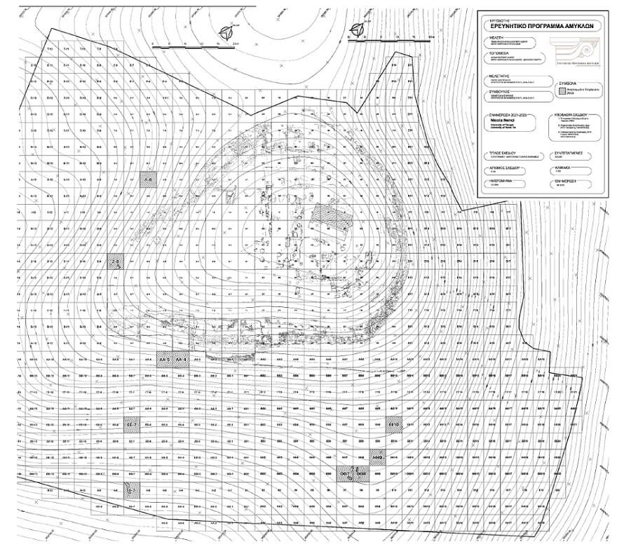
The objectives of this year's excavation works, which took place between 14.7.2023 and 18.8.2023, were the verification or not of the findings of the geophysical surveys carried out last year (2022). For the excavation works, the proposed system of the American School of Classical Studies for the excavations of Corinth (Corinth Excavations Archaeological Manual) was used, along with the Harris Matrix system. Deposit context numbers (DCN) were determined to identify the layers.
More specifically, on the southern slope of the hill, two areas of particular interest have been determined for data that will be obtained regarding the occupation of the area during the antiquity. The area in the ΑΑ -4, ΑΑ -5 squares was chosen, where it is supposed that the southern end/side of the so-called ‘South Building’ can be identified. In both squares, the excavation works proceeded in parallel and to a depth of more than 0.50 m. The removed top soil (DCN 01, DCN 101) essentially consisted of the soils from recent excavations of the current project in the area of the Geometric peribolos. The lowest layer (DCN 04, DCN 103) corresponded to the natural bedrock (kimilia), which has a north-south incline. Directly above and in association with the natural bedrock (kimilia), the ancient layer (DCN 02, DCN 102), reddish-grey in colour, was located, which contained little pottery, mainly of Geometric and Archaic periods and a few tiles, indicating possible interventions in the natural bedrock (kimilia) for the construction of structures in the same period.
In the south-eastern area of the recently acquired territory surrounding the Amyklaion, traces of possible structures were identified by the geophysical surveys. For this purpose, the following two squares were initially determined: ΘΘ8 and ΗΗ9. In particular, the ΗΗ9 square has a moderate southward incline. The modern layer (DCN 301) consisted of soils of brownish-grey colour, containing pebbles, small and large stones, tile fragments and pottery dating between the Geometric and Byzantine periods. Immediately below the top soil, a layer was revealed which extends across the entire square and is characterized by the strong presence of pebbles and cobbles (DCN 302). The soil was light brown in colour with a yellowish hue, its composition was hard and clayey with a soapy texture, which also contained small stones and very little pottery, mainly of Geometric and Archaic date. Its identity remains undetermined, as it is either a road infrastructure or a geological layer. Finally, along the southern side of the square, the natural conglomerate rock was uncovered.
Of the two squares, however, the most interesting one is the ΘΘ8 square. The modern layer (DCN 201) consisted of soils of dark brown colour, dry, loose and disturbed, and contained a small amount of pottery from the Middle Helladic to Byzantine periods, tiles, several stones and pebbles. The removal of the top soil and subsequently, of the overlying DCN 202 layer revealed a pebbly layer (DCN 204) across the western side, running north to south. The soil was light brown in colour with numerous small-sized pebbles. This layer is identical to the DCN 302 one of the HH9 square. In addition to the pottery dating between the Early Helladic and Byzantine periods, a shallow pit burial, measuring 0.70 x 055m, of an adult with two vases as burial offerings, was found in the north-western quarter of the square. More specifically, the skeleton, placed in a north-south orientation, survives at 1.38 m in length and 0.38 m in width, and is in a supine position. The skull is turned to the west, the left hand is bent towards the abdomen, while the right hand is extended parallel to the body and in contact with the vessels placed laterally on the right hip. With regard to the vases-burial offerings, they are a medium-sized beaked prochous and a small-sized, dark-coloured, one-handled cup, both of which probably date to the Middle Helladic period, thus, by extension, dating the burial itself to the same period. It seems likely that this is a roadside burial of the Middle Helladic period and that the pebbly level on which it was found, is a road continuing further north.
In order to investigate the above hypothesis, as well as the possible existence of more burials in the area, a new square, the ΘΘ7 one, was determined, which is adjacent to the ΘΘ8 square immediately to the west. More specifically, the removal of the modern layer (DCN 701) revealed a pebbly layer (DCN 703), which is similar to and a continuation of that (DCN 204) of the ΘΘ8 square. On the south-eastern side of the square and in a common orientation with Burial 1 of the ΘΘ8 square, a total of six medium-sized stone slabs (STRUCTURE 707) were uncovered, arranged vertically and forming a right angle. The soil within the boundaries of the slabs (DCN 704) is light brownish in colour, soft, with several stones and pebbles within it, and shares many characteristics with the soil surrounding the skeleton of the ΘΘ8 square (DCN 213). Little pottery, mainly of Archaic date, was collected, and no bone was found. This structure, with surviving dimensions of 1,18 x 0,28 m, is similar to a cist grave, probably of a child’s (Burial 2) due to its short length.
Additionally, on the north-western side of the square, underneath the DCN 702 layer, a concentration of medium-sized rough stones with tile fragments in places is found. A similar concentration of stones with tile fragments occurs on the south side. In particular, a medium-sized stone is revealed and around it, stones of smaller size and pebbles with tiles in between. These assemblages probably indicate the presence of a burial in these areas.
In order to investigate the hypothesis of the presence of a pebbly surface in the area, in continuation of that in the ΗΗ9 and ΘΘ7-8 squares, which was probably a road, a new square, the ΕΕ10 one, was determined on the south-eastern side of the hill, within a short distance north of the ΗΗ9 and ΘΘ7-8 squares. With the removal of the modern layer (DCN 401), animal bones, numerous tile fragments, charcoal and plenty of pottery were collected. At a depth of approx. 0.30 m from the surface of the hill, a pebbly layer (DCN 404) was indeed found, similar to that of the HH9 (DCN 302) and ΘΘ7-8 (DCN 204, 703) squares, and was subsequently removed to reveal the kimilia ('horizontal' layer- DCN 407) from the middle to the southern end of the square.
On the southern slope of the hill, a new square, the II -7 one, was determined. The objectives of the excavation works on this square were to investigate the anomaly detected in this area during last year's geophysical surveys. The top soil (DCN 501) was removed, which contained pebbles, small and medium-sized stones, a large number of tiles, pottery dating between the Early Helladic and Byzantine periods, modern and iron objects. The soil was greyish-brown in colour, very hard and crumbly.
On the north-western side, a change in the stratigraphy occured, as the soil was now thinner and more compact and consisted of smaller and larger pebbles (DCN 503). The finds were also different, as a remarkable amount of metal artefacts, animal bones, pottery and tiles were found, indicating the existence of a pit/deposit in situ. Of the finds identified, an iron spearhead and a bronze pin, a lead human figure with a shield and an incised bone plaque stand out.
The finds were irregularly arranged on the ground, at different levels, often surrounded by small or large stones or tiles, reminiscent of a fill where the objects have been discarded. Indeed, the continuation of the excavation works in the area heading south, confirmed the hypothesis that this was a deposition of objects within a natural ditch in the kimilia. Furthermore, although it was initially thought that the deposit was only located in the north-western side of the square, it can be concluded that it extends towards the southern boundary of the square, creating a narrow, curving shape to the south. The width of the ditch varies between 0.50m. and 0.85m., and its maximum depth is 0.48m. It is probably a ditch of discarded artefacts of purely Archaic date, related to the function of the sanctuary during the Hyakinthia festival as indicated by the numerous lead votive wreaths and human figures, animal bones such as the jaw and horns of a goat, iron spits, spear- and arrowheads, knives as well as miniature vases. To the south of the ditch, a horizontal double row of rough, medium-sized stones was revealed, probably constituting part of a wall (STRUCTURE 507).
In the middle of the south-western slope of the hill, the ΕΕ -7 square was excavated. The modern layer (DCN 601) consisted of dark brown soils, soft and sandy, containing small and large stones, cobbles, tile fragments and roots. Bones, fragments of modern glass and bronze objects and pottery dating between the Early Helladic and Byzantine periods were collected. During the removal of this layer, the natural rock was revealed with its gradations at various levels.
West of the hill, within a short distance from the main entrance of the sanctuary, the excavation works concentrated on the Λ -6 square, the main objective of which was the investigation of the anomaly detected during the geophysical surveys. This anomaly should probably be identified with the bronze animal foot- possibly of a griffin, from a miniature tripod, which was found in the modern layer (DCN 801). The excavation works focused on the western diagonal part of the square and stopped at a depth of ca. 0,50 m. Of the soils removed, derived exclusively from the disposals from the excavations of the current research project, little pottery was found, mainly of Geometric and Archaic date.
Lastly, at the southern end of the sanctuary, in the interval between the western peribolos and the ‘South Building’, the Ζ -8 square was investigated. The objective of the excavation works was to identify a possible structure at this point, taking into account the results of last year's geophysical surveys. In particular, the latter showed anomalies in the middle of the southern side of the square. At first, the modern layer (DCN 901), approx. 0,15m. in width, was removed, consisted of dark brown, sandy and soft soils with a few pebbles, cobbles, small stones and tile fragments in between. Bone fragments were collected, one of which showed signs of burning, pottery of different periods, mainly Geometric and Archaic, nails and two round stones, probably jug-stoppers. The ancient- reddish layer with a strong presence of pebbles and cobbles (DCN 902) was uncovered in the northern half of the eastern side of the square.
In the middle of the south-eastern side of the square, a concentration of large-sized unworked stones was discovered (DCN 903), in which a significant amount of bones, little pottery and tiles, as well as some metal finds, such as parts of a knife, were found. It was decided to gradually remove the stones and tiles, during which a quantity of Archaic pottery, tiles and bones were collected. After the removal of this material, parts of walls made of medium-sized stones were revealed, arranged in a row creating a right angle towards the center of the square. This was probably part of the foundation of a small structure, due to the thickness of the walls, which extended to the west (STRUCTURE 907). The anomaly of the geophysical surveys in the middle of the south side should probably be identified with the presence of the structure at this point.
For the more accurate recording and collection of information and data of the systematic excavation, the excavation squares and the site as a whole were documented, designed and mapped with the use of innovative technologies (use of drone, photogrammetry and orthophotography with topographic georeferencing points and the relevant software Pix4D and metashape). Additionally, the integrated documentation system, as well as the Geographic Information System (GIS) of the Amykles Research Project, were completed and enriched with the new data.
II. Geophysical surveys
Geophysical measurements have been carried out in the surroundings of the sanctuary of Amyklaion by researchers from the University of Münster (Germany) between July 31 and August 11. The measurements were a continuation of the measurements carried out in 2022 and focused on the exploration of the eastern slope of the hill. Non-invasive geophysical methods have been employed, namely magnetic measurements, ground penetrating radar (GPR), and electrical resistivity tomography (ERT). These three methods are commonly applied to archaeological prospection, but their usefulness for imaging the subsurface is dependent on the local geological structure and the archaeological remains sought.
The magnetic measurements covered an area of about 5200 sqm east and south of the sanctuary. A two-channel cesium magnetometer (G858 by Geometrics) was used and the sample spacing was <25 cm along profile and 50 cm between profiles. However, in some areas the measurements were hindered by steep slopes and dense vegetation. In the central part of the southern slope, the results show numerous small magnetic anomalies, which indicate human activity, but form no clear pattern. We also re-measured a small area at the southern slope, where a distinct anomaly was found in 2022. The excavations revealed that it was caused by numerous metal pieces in the subsurface. The eastern slope could be only investigated partly because of the steep terrain. Also, the metal fence at the boundary of the property cause magnetic disturbances. The remaining area shows only few small-scale magnetic anomalies, in contrast to the findings at the western slope.
GPR measurements were carried out on 53 profiles using a dual frequency antenna (300/800 MHz) from GSSI with an RTK GPS positioning system. The penetration depth of the radar waves was less than a meter due to marly sediments. In some areas, the data shows clear signs of subsurface structures. Based on the data acquired in 2022 and from the excavations, these structures are sometimes associated with human intervention in the subsurface.
In total, 31 ERT measurements have been carried out using a 48 channel multi-electrode resistivity meter (IRIS instruments). The length of the profiles varied between 20 m and 48 m. The results give a good insight into the structure of the hill down to a depth of several meters. Although many structures will be due to the geology, there are numerous small-scale structures, which could be due to human interaction. From the excavation works, it is concluded that parts with high electrical resistivity often indicate conglomerate rock, which was also used for construction purposes.
III. Material study
The study was conducted in modern Amykles in two periods (from 27 February to 7 March and from 22 July to 19 August 2023) by a team, in charge of which was Dr. Adrien Delahaye (École française d'Athènes), in collaboration with Dr. Christian Mazet (Sapienza – Università di Roma), and Vicky Katsichti, Kalliopi Kanellopoulou (conservators) and Yannis Nakas (designer).
After the processing in 2022 of the ceramic material from the excavations of 2020, 2017, 2016 and 2015, the material from the excavations of 2021 and 2019 was integrated this year into the database and documented. Preliminary research and incorporation of material from the 2020 excavations has also been completed, while processing of material from the 2018 excavations has begun but is not yet complete. A total of 339 new entries of ceramic objects and 54 figurines and antefixes were made in the database, bringing the number of sherds and clay objects to 1337 and 90 respectively, and the total number of objects to 1427.
One of the major challenges of the works of 2023 was the advancement of the study of the thousands of miniature vases unearthed in the sanctuary, mainly during the excavations in the southern sector between 2018 and 2020. To this end, a typology of seven categories was created: aryballiskoi, small lakainai, krateriskoi, kanthariskoi, hydriskae, perirrhanteria and other vase shapes. This typology was used to count the thousands of fragments, with a minimum number of 7121 objects having been determined, well above that from the preliminary post-excavation counts, bringing the total to about 5000 objects. A representative sample per typological group was added into the database, designed and their clay was systematically documented using a Dinolite microscope.
Under the supervision of Evangelia Kiriatzi (director of the Fitch Laboratory), the transfer of 53 ceramic sherds to the Fitch Laboratory in Athens for analysis in the framework of the archaeometric analysis programme (petrography and WD-XRF) was completed, in collaboration with the research team of the Mount Lykaion and the Fitch Laboratory (BSA).
Lastly, it should be noted that the metal and bone findings from this year’s excavation works at Amyklaion were transferred to the metal laboratory of the Ephorate of Antiquities of Laconia in Sparta, while the ceramics were transferred to the storage of the Ephorate of Antiquities of Laconia in Amykles, where they are kept. In the same storage and in special boxes, both the skeleton and the fragments of the vases-burial offerings of the ΘΘ8 square were also transferred, which were preserved and mended by Kalliopi Kanellopoulou.
With the support