Excavation Reports
2022 Report
22-11-2022 11:031. Geophysical - Archaeological research
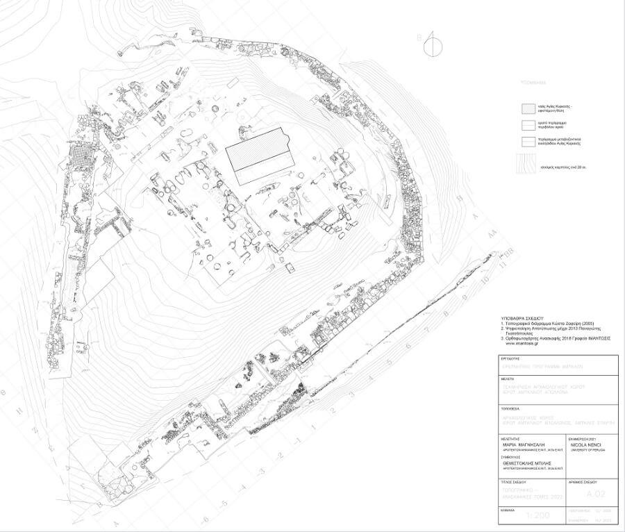
The aims of the work in 2022 were the geophysical research of the subsoil in the areas added to the archaeological site after the completion of the expropriation process of the relevant properties on the western and southern slope of the hill of Ag. Kyriaki, the mapping of the area through the scanning of the surface with a laser beam and LIDAR (LIght Detection And Ranging) technology, as well as the detailed surface cleaning of the new areas. The purpose of this work was to identify archaeological remains and delineate the new archaeological areas to better prepare the excavation of the newly acquired part of the archaeological site, where it is assumed that there was infrastructure supporting the sanctuary's operation, and to create a highly accurate 3D Digital Elevation Model of the wider area.
In parallel with the detailed surface cleaning of the new areas, initially on the west side and then on the south (fig. 1), geophysical measurements were carried out in the surrounding area of the Amyklaion by researchers from the University of Münster (Germany). Various non-invasive geophysical methods were used, including magnetic measurements, ground penetrating radar (GPR) and electrical resistivity tomography (ERT). These magnetic measurements covered an area of approximately 7600 m2 west and south of the sanctuary. In some places the research was not carried out due to the strong draw of the slopes and dense vegetation. The vertical gradient was measured using a fluxgate gradiometer (FEREX), and a two-channel cesium magnetometer (G858 by Geometrics), respectively. Both instruments gave data of comparable quality. The sample spacing was <25 cm along profile and 50 cm between profiles. In the olive grove, it was not possible to cover the area fully with parallel profiles. The data shows numerous scattered magnetic anomalies in the West of the sanctuary, which in some cases forms linear structures. A number of strong dipolar anomalies indicates local concentrations of highly magnetized material. The density of anomalies decreases towards the South. In the Southeastern part, in general fewer anomalies are visible, but locally there is a remarkable network of weak anomalies, which could indicate edificial structures.
The GPR measurement were carried out on several long profiles throughout the area. At some spots, dense parallel profiles were measured in order to achieve a 3D view of the subsurface. We used a dual frequency antenna (300/800 MHz) from GSSI with an RTK GPS positioning system. The penetration depth of the radar waves usually less than a meter. It was limited by an electrically conductive layer, probably marly sediments. Nevertheless, the data shows clear signs of subsurface structures. Also the boundary between to upper layer and the lower conductive layer is visible.
For ERT measurements, we used a 48 channel multi-electrode resistivity meter (IRIS instruments). The measurements were carried out on 21 profiles in total, having a electrode spacing of 1 m or 0,5 m, respectively. In the West, an area was covered with dense parallel profiles (1 m profile spacing), which enables us to do a 3D analysis of the data. The same area was also covered by dense GPR profiles. Unexpectedly, the apparently dry soil did not impede the resistivity measurements and a good data quality was achieved. Many ERT results show a thin cover layer with high resistivity and a low resistivity layer underneath, probably indicating marly sediments. The highly resistive top layer could contain building remains and its depth varies locally. Further data analysis will investigate, if these variations could show terracing of the hill.
The detailed rendering of the terrain of the Agia Kyriaki hill area was achieved by applying photogrammetry and 3D LiDAR laser scanning techniques to produce orthophotography and a high resolution digital terrain model. The work was carried out on 29 and 30 July by the Laboratory of Archaeometry of the Department of History, Archaeology and Management of Cultural Assets of the University of Peloponnese.
The aerial photography and LiDAR scanning of the area was carried out using the DJI, Matrice 300 RTK. The photogrammetric mapping was implemented with a Zenmuse-P1 high resolution camera and the scanning with a Zenmuse-L1 laser scanner (Airborne light detection and ranging -LiDAR). For more accurate georeferencing of the data - a cloud of points of both methods, used a GNSS receiver to record seven (7) fixed points in the area. For both the photographic survey and LiDAR scanning, four flights were performed: Two Zenmuse P1 flights lasting one hour in total and two Zenmuse L1 flights. The photographic survey resulted in the collection of 1244 photographs while the LiDAR L1 scan resulted in the creation of a single cloud of 446,617,649 points. Data processing of the two approaches was carried out independently and simultaneously. In the case of the L1 scanner, the georeferenced dense point cloud was processed using ArcGIS Pro software. The first step was the classification of the point cloud in order to clean and extract the ground data. The main output of this processing is the digital terrain model. All data were collected in the Greek projection system HGRS '87.
The processing of the photogrammetric data of the site was initially processed for their appropriate georeferencing in specialized software of ΣμηΕΑ, resulting in the production of a georeferenced dense point cloud. Agisoft Metashape photogrammetry software was used to generate the orthomosaic, georeferenced orthonormal aerial photograph with natural colors and the digital elevation model (DEM) from the point cloud. From this initial combined study of the orthomosaic, the digital soil model and its imagery, which form the soil morphology in this area, ten points of high probability of association with archaeological targets are indicated, which require further study and analysis with additional techniques.
In the context of the removal of the soil that originated from the earlier excavations along the southern flank of the archaeological site, the continuation to the east of the retaining wall that was identified during the archaeological investigations of 2021, was revealed. As in the already known section, in the new section of approximately 42m length and with a maximum surviving height of 1.22m, it was found to be a dry-stone structure, the construction technique of which dates to modern times and the period when the hill was used for agricultural activities. The detailed examination of the soils recovered a large number of finds, mainly pottery of all periods mixed with modern litter. A roof tile fragment with an engraved inscription of the 5th century BC from which the letters ΙΜΑΧΟΣ survive, the head of a snake from an Archaic clay figurine and fragments of bone tiles with engraved decoration, stand out.
For the more accurate recording and collection of information and data of the archaeological site as a whole, it was documented, designed and mapped with the use of innovative technologies (use of drones, photogrammetry and orthophotography with topographic georeferencing points, and the relevant software Agisoft Metashape). In addition, the integrated documentation system and the Geographical Information System (GIS) of the Amyklaion Research Project were supplemented and enriched with the new data.
2. Material Study
A team, led by Adrien Delahaye (French School of Athens) and Christian Mazet (French School of Rome), and collaborators Vicky Katsichi (conservator), Yannis Nakas (designer), Maël Lebas, Diana Mélinou, Jordan Metton and Valentin Viniger (archaeology students at the University of Rouen) and Paul L'Évêque (archaeology student at the University of Paris 1 Panthéon-Sorbonne), travelled twice to Sparta and Amykles (from 28 February to 12 March and from 25 July to 20 August 2022) to study the ceramic material from the sanctuary of Apollo Amyklaion.
673 new sherds were integrated in 2022 into the new database system of the research project (AMREP - Augmented Mixed Reality Educational Platform). Each object was circumscribed, measured, photographed, its clay was characterized according to the Munsell guide and documented with a portable microscope (Jiusion Digital Microscope 40, 1000x); 26 fragments were preserved, and 123 were drawn.
The research revealed additional data that determine the chronological range of the votive offerings of the sanctuary, documenting the period of its heyday and its monumental configuration, from the beginning of the 7th to the 4th century BC. Furthermore, this work complements that of Vicky Vlachos on the Early Geometric and Geometric pottery. Particular attention was paid to the material from the southern sector of the hill of Agia Kyriaki, at the junction between the monumental enclosure of the late 6th century BC and a part of the earlier enclosure dating to the late 8th and early 7th century BC. In this area large quantities of votive offerings were found, as well as reliable stratigraphic units dating to the end of the 8th to the beginning of the 7th century BC. The investigations add to our knowledge of the transitional phase of Laconian figurative pottery, from the Late Geometric to the Laconian I phase, as well as the typology of the Laconian Droop cups, or "Doric cups" according to Conrad M. Stibbe.
A preliminary study was also carried out on the Archaic Laconian fragments of relief vases, as well as on the thousands of miniature vases. To this end, a representative sample was integrated, studied and designed in order to lay the foundations of a typology that could later be used to classify the whole of the micrographic vases, one of the most important deposits of this type discovered in Laconia. Finally, a box of selected and characteristic shreds was formed that will allow researchers to benefit from a reference set for the ceramics of the site and, more broadly, of Archaic and Classical Laconia. The above work was carried out with the support of the French School of Athens, the Mediterranean Archaeological Trust and the Ephorate of Antiquities of Laconia, which provided suitable space for the study, in the department's warehouse.
The findings of small crafts (metal and bone) that came from the recent excavation work at the Amyklaion were studied between 08-19.08.2022 at the conservation laboratory of the Ephorate of Antiquities of Laconia, where they are stored. The director of the Amyklaion Research Project with the assistance of the archaeologist Mrs. Rafailia Fotiadou and the conservator Mrs. Polytimi Diamantopoulou, recorded and photographed all the preserved objects while filling in the data entry forms in the database of the research project of all the 497 metal findings that have been registered so far.
With the support