Excavation Reports
2013 Report
30-09-2013 13:57The volume of soil removed, ranging in thickness from 1.10 m. to 1.20 m., belonged to a later fill containing many recent objects, among them nails, broken roof tiles and lime-plaster fragments, as well as pottery of various periods, from the Geometric to the Byzantine. Below the recent fill extended the familiar surface of the yellowish porous bedrock. As in the area of the Late Antique buildings, the layer was ascertained to represent the upper level of the natural surface of the hill.
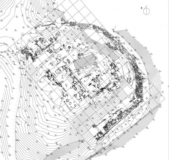
At about the midpoint of the upper level of Agia Kyriaki hill, the natural interface between the geological stratum of the pebbled surface in the south half and the solid porous surface in the north was revealed, running diagonally east-west. This interface, in which the north wall of the church is also founded, meets almost at right angle a cutting in the pebbled surface immediately east of the church. In all probability this cutting belongs to the subfoundation of the Throne and extends correspondingly into grid-squares Ι-Θ 8. That is, the straight line it forms for a length of about 20 m. meets at its south end and at right angle the imagined eastward projection of the existing part of the krepis of the Throne. The excavated area yielded a small quantity of pottery of all periods and a fragment of a palmette antefix of Hellenistic times.
At the point of contact between grid-squares Κ-Λ 5, a wall was revealed (l. 1.60 m., th. 1 m. and h. approx. 0.60 m.), constructed of small and medium-size fieldstones, tile fragments and lime plaster. Both the technique of its construction and the composition the plaster refer to the eleventh century AD, that is the same period as the two apses found respectively south of the krepis and north of the church.
An undisturbed archaeological level of yellow argillaceous earth, rich in prehistoric pottery mainly of the Early Helladic period, was removed from exactly above the solid porous bedrock in grid-square Κ 6 and the east part of grid-square Κ 5. This fill should be related to the Early Helladic settlement and the earliest use of the hill. Indeed, in the course of removing the level from grid-square Κ 5, a rubble-masonry wall of medium-size fieldstones laid in a course was uncovered, parallel to the north wall of the church of St Kyriaki. This careless construction, about 1.50 m. long, most probably belonged to a house in the Early Helladic settlement. Likewise, in grid-square Κ 6, on the natural solid fine-pebbled level of the hill and along the length of the north wall of the church, two semicircular shallow pits were found, similar to those uncovered at other points in previous years.
At about the centre of grid-square Κ 5 a rock-cut rectangular construction orientated northwest-northeast (l. 1.95 m., w. 0.54 m., depth 1.20 m.) was brought to light. Its walls, 0.30 m. thick, are of schist slabs, mud-bricks and mortar, coated with greyish-white plaster creating exceptionally smooth internal surfaces. From these features the construction is possibly identified as a cistern, even though its typology would not rule out the possibility that it is a tomb. The fill removed from its interior was disturbed and contained a considerable quantity of Byzantine glazed pottery. Also found in the interior was half of a worked marble plaque (l. 1.28 m., w. 0.94 m. and th. 0.10 m.), as well as the fragment of one other plaque from the bedding of a Doric column of the Throne (l. 0.17 m., w. 0.13 m., th. 0.04 m.).
In the area between the church and the corner formed by two conglomerate boulders known from earlier excavations, specifically at the point of contact between grid-squares Κ-Λ 3-4, a cavity in the bedrock (l. 10 m. and w. approx. 2.50 m.) was uncovered. This is due on the one hand to ancient and later interventions, and on the other to the levering of the soil by the roots of the trees that grew there. However, the opening of it should be associated mainly with the excavations conducted here in 1925 by Ε. Buschor (Buschor E., Massow W. von, Vom Amyklaion, AM 52, 1927, 25-26, fig. 12). The stratigraphy of the fill in the grid-squares in this area was particularly disturbed. A cist grave, without grave goods, with schist capstone and orientated north-south (l. 2.47 m., w. 0.80 m., depth 0.32 m.) was unearthed at the centre of grid-square Λ 3. Constructed of schist slabs and tile fragments, its north edge has been cut in the porous bedrock. It dates most probably from Byzantine times and three adult skeletons were found inside it.
In the wider area to the west and northwest of the church, six relatively shallow figure-eight and semicircular pits were located, their interior disturbed by later fill.
Along the south side of grid-squares Μ 2-5, under the recent fill, a wall of overall length about 15 m., maximum width 1. m. and, standing to a height of 0.50 m. was uncovered. It is constructed of small and medium-size fieldstone, tile fragments and lime-plaster mortar. The technique brings to mind the two apses, south of the krepis and north of the church, as well as the aforementioned wall in grid-squares Κ-Λ 5. These constructions are related chronologically and could be dated to the eleventh century AD. It should be noted that the wall in grid-squares Μ 2-5 is patchily preserved. However, in those parts that have not survived its foundation trench cut in the natural porous bedrock is visible. Its west end was located in grid-square Μ 2, while in grid-square Μ 5 its southwards turn at right angle can be seen. From there the continuation of the south branch was followed for a length of 1.10 m. inside grid-square Λ 5.
North of this particular wall, five shallow circular pits were found, the interior filling disturbed by later fill. The westernmost pit, at the junction of grid-squares Μ-Ν 1-2, is about 1 m. in diameter and constitutes the south limit of a wall that extends northwards. This wall, approximately 6 m. long and 1.40 m. thick, is constructed of roughly-dressed small and medium-size fieldstones of conglomerate and limestone, with earth as mortar. The technique of its construction recalls the inner structure of the Archaic precinct wall (peribolos) of the sanctuary, with which it is very possibly contemporary. It runs parallel, at a distance of 6.30 m., to the Roman wall in grid-squares Ν-Ξ 3. In all likelihood these are the two sides of the entrance to the sanctuary, the position of which in this part of the hill was expected, also for geomorphological reasons. To the north of the west wall, a destruction level was found, consisting entirely of roof tiles. These could be interpreted as attesting that the sanctuary entrance was in the form of a roofed propylon.
The propylon must have been destroyed and abolished in the Early Byzantine period, as deduced from the existence of two graves in the middle of the entrance.
Surely one of the most important results of researches at Amyklai is the discovery in the northwest part of the hill of the westward continuation of the monumental peribolos of the sanctuary. And this because it refutes earlier hypotheses on its horseshoe plan and on free access to the sanctuary from the west side. This section of the peribolos, about 5 m. long, was located at its point of contact with the north end of the west wall of the entrance. Orientated north-south, it was revealed to a height of two courses, about 1.50 m. thick, and is constructed of roughly-dressed large conglomerate fieldstones. Directly west of and abutting it, part of the subfoundation of one other robust construction was excavated, which appears to occupy a square area of side approx. 4.50 m. (fig. 5, white square). In all probability this is a building that reinforced the peribolos and the entrance to the sanctuary.
In grid-squares Π 3-4, Ν 8, Μ 10, Z-H 11, A 8, -A 8, A 5 excavation trenches were opened along the length of the passage immediately outside the Archaic peribolos-monumental retaining wall encircling the hill of Agia Kyriak on its north, east and south sides. Aim of these works was to uncover the foundation trench of the precinct wall along its visible exterior flank and to resolve issues relating to its dating.
Found in the excavation trenches in grid-squares Π 3-4 was a Byzntine wall (l. 2.60 m., th. 0.50 m.) that had already been located by Ε. Fiechter in the early twentieth century and is constructed of small fieldstones and roughly-dressed stones.
In grid-squares Ν 8 and Μ 10 fill disturbed by later interventions was removed, of maximum thickness 1.10-2 m. Uncovered at a depth of about 0.90 m. in grid-square Ν 8 were three of the four cement bases of the recent metal water-tank that had been removed from the site in 2005, in the course of clearing operations. The ancient level below these included a small quantity of Early Helladic and Geometric pottery with parts of zoomorphic and Psi-type Mycenaean figurines. The bedrock on which the Archaic peribolos stands slopes steeply northward here (to a depth of 0.90 m.-1.10 m.), ruling out the existence of a passage.
This situation is observed also in grid-square Μ 10, where the surface of the bedrock slopes northward to a depth of 1.35 m. to 2.10 m. Furthermore, it was ascertained that in the southeast corner of the grid-square, between the two sections of the peribolos that meet there, there is a void about 0.50 m. long. Thus it is deduced that these two sections of the peribolos are independent of each other (peribolos section Α: grid-squares Μ 9, Ν 8, peribolos section Β: grid-squares Ι-Κ-Λ 10).
Nonetheless, the existence of a passage outside the peribolos is confirmed in grid-squares Ζ-Η 11. Here and for the entire width of the trenches, the flat surface of the cut porous bedrock in which the Archaic peribolos was founded, was exposed directly after the removal of the surface layer of the modern fill, at a depth of about 0.30 m. Indeed, the outside of the peribolos in grid-square Ζ 11, with the visible disturbance of the masonry, generates the hypothesis that at this point, where the curved end of the preceding Geometric peribolos also terminates, an entrance must have existed.
The existence of the same Archaic passage over the entire width of the present terrace outside the peribolos is confirmed on the south side of the hill too. Specifically, in grid-squares Α 5, Α 8, -Α 8, as well as in grid-square Α 2, the flat surface of the cut porous bedrock, of maximum width 7 m., appears. Particularly notable are the finds from grid-square Α 5, as the stratigraphy has not been disturbed by later intervention. On the north side of the trench the courses of the subfoundation of the peribolos are bedded in the first level of the ancient fill, approx. 0.15 m. thick, which contains Geometric and Archaic pottery. Beneath this is the second level, approx. 0.10 m. thick, with pottery of prehistoric, Protogeometric and Geometric times, while the lowest third level, 0.60 m. thick appears, yielded exclusively pottery of the Early Helladic and the Middle Helladic period. Found in the second level were sporadic concentrations of ash and one bronze Geometric warrior figurine (h. 0.10 m.).
The picture from grid-square Α 8 is similar. Along its north flank was revealed a large number of fieldstones defining the continuation of the trench southwards. At the centre of the adjacent grid-square –Α 8, the concentration of randomly fallen fieldstones mixed with ash and plaster points to some later intervention in the space and disturbance of the stratigraphy down to the level of the Early Helladic pottery.
With the support